


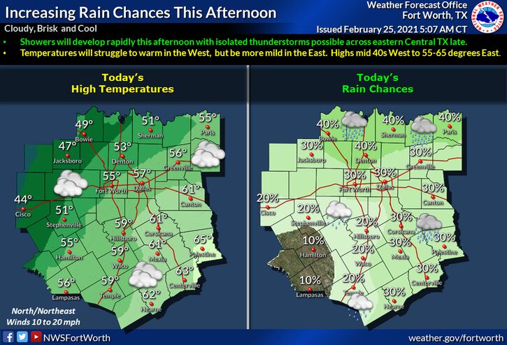
Hopkins County Weather Forecast for February 25th, 2021

[adning id=”33097″]
A brisk, cloudy, and cool day is expected for your Thursday wake of Wednesday’s cold front. Showers will increase across most of the area this afternoon. Highs will range from between 45 to 55 degrees west of I-35, to between the mid 50s and lower 60s further east. By late afternoon, a rumble of thunder may be heard from time to time across eastern Central Texas. No severe weather is expected this afternoon.
Today
A chance of showers between 2pm and 4pm, then a chance of showers and thunderstorms after 4pm. Cloudy, with a high near 57. East northeast wind around 10 mph, with gusts as high as 20 mph. Chance of precipitation is 40%.
Tonight
Showers and possibly a thunderstorm before midnight, then showers and thunderstorms between midnight and 4am, then showers and possibly a thunderstorm after 4am. Some of the storms could produce heavy rainfall. Low around 43. Northeast wind around 10 mph. Chance of precipitation is 100%. New rainfall amounts between 1 and 2 inches possible.
Friday
A chance of showers and thunderstorms. Cloudy, with a high near 57. East northeast wind 5 to 10 mph becoming west southwest in the afternoon. Chance of precipitation is 50%. New precipitation amounts between a tenth and quarter of an inch, except higher amounts possible in thunderstorms.
Friday Night
A 20 percent chance of showers before midnight. Mostly cloudy, with a low around 48. South wind around 5 mph becoming north after midnight.
Saturday
A slight chance of showers, then showers likely and possibly a thunderstorm after noon. Cloudy, with a high near 65. Southeast wind 5 to 10 mph. Chance of precipitation is 60%.
Saturday Night
Showers and thunderstorms likely. Cloudy, with a low around 59. South wind 10 to 15 mph, with gusts as high as 20 mph. Chance of precipitation is 70%.
Sunday
Showers likely and possibly a thunderstorm before noon, then showers and thunderstorms likely after noon. Cloudy, with a high near 67. South southwest wind around 10 mph becoming north northeast in the afternoon. Chance of precipitation is 70%.
Sunday Night
Showers and thunderstorms likely before midnight, then showers likely and possibly a thunderstorm after midnight. Mostly cloudy, with a low around 49. North northeast wind around 10 mph. Chance of precipitation is 60%.
Monday
Showers likely. Mostly cloudy, with a high near 56. East northeast wind 10 to 15 mph, with gusts as high as 20 mph. Chance of precipitation is 60%.
Monday Night
A 40 percent chance of showers and thunderstorms. Mostly cloudy, with a low around 45.
Tuesday
A 20 percent chance of showers. Partly sunny, with a high near 59.
Tuesday Night
Mostly cloudy, with a low around 47.
Wednesday
A 30 percent chance of showers. Partly sunny, with a high near 67.
[adning id=”33207″]