


Hopkins County Weather Forecast for September 9th, 2020

[adning id=”33097″]
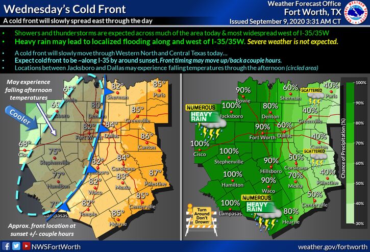
A cold front will begin to make its way through North Texas today! Widespread showers and thunderstorms are expected through the day with heavy rain likely for the areas along and west of I-35/35W. This may lead to localized flooding this afternoon and evening. The cold front should slowly move east through the day and be roughly along the I-35 corridor by sunset…expect falling temperatures behind the front.
[adning id=”33207″]
Today
A 40 percent chance of showers and thunderstorms, mainly after 1pm. Mostly cloudy, with a high near 88. East wind around 5 mph becoming south southeast in the afternoon.
Tonight
A 30 percent chance of showers and thunderstorms. Cloudy, with a low around 73. Southeast wind around 5 mph becoming north after midnight.
Thursday
A 30 percent chance of showers and thunderstorms. Mostly cloudy, with a high near 84. North wind 5 to 10 mph.
Thursday Night
Mostly cloudy, with a low around 67. North wind 5 to 10 mph.
Friday
A 20 percent chance of showers. Partly sunny, with a high near 86. North wind 5 to 10 mph.
Friday Night
Partly cloudy, with a low around 67. North wind around 5 mph becoming calm in the evening.
Saturday
A 20 percent chance of showers and thunderstorms. Partly sunny, with a high near 87. Calm wind becoming north northwest around 5 mph in the afternoon.
Saturday Night
Partly cloudy, with a low around 70. North wind around 5 mph.
Sunday
A 20 percent chance of showers and thunderstorms. Mostly sunny, with a high near 87. North northeast wind 5 to 10 mph.
Sunday Night
Mostly cloudy, with a low around 68.
Monday
A 20 percent chance of showers. Partly sunny, with a high near 85.
Monday Night
Mostly cloudy, with a low around 67.
Tuesday
A 20 percent chance of showers. Mostly sunny, with a high near 83.
[adning id=”33207″]